| Welcome to ECOMARG PROJECT website |

|
 |

|
 The ECOMARG research team studies in the selected areas in which all proposed activities for the different research teams are designed to inter-relate and complement each other, resulting in a characterization of the benthic-demersal ecosystem, including habitat description, biodiversity, structure and dynamic and synthesized description using meta-models.
In a first phase, the research team studies the morpho-sedimentary and bathymetric characteristics of the study area. Further on, it aims at the integrated study of the communities of the three main components of the benthic domain (infauna, epifauna and suprabenthos) and demersal fish, based on the systematic determination of the involved taxa, and the joint analysis of abundance and biomass quantitative data and abiotic factors of the water column and the sediment, as determinants of its variability.
 This methodological approach offers an overview of the biodiversity of the ecosystem and the structure and distribution of its communities. The trophic ecology of the dominant fish and crustacean species is used to estimate the energy fluxes, the consumption, and niche overlap between higher trophic groups. All this information, together with the analysis of the impact of the fisheries being carried out in the area, are integrated in a mass balance trophodynamic model (Ecopath) which allows explanation and synthesis of the characteristics of the ecosystem, comparison with other similar ones and prediction of the consequences of the putative management measures which may be adopted in each particular area. modelo trofodinámico
The main objectives of the projects can be summarized as follows:
- Morpho-sedimentary study of the continental margin
- Dynamic and characteristics of the water masses in the study areas
- Characterization of benthic and demersal communities
- Trophic ecology of fish and crustaceans
- Study of the impact of fisheries working in the area
- Generate trophodynamic models of the ecosystem
- Writing proposals for sustainable development
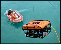
 The projects include important technological innovations, which are necessary to tackle the study of deep hard bottoms. Among them, the use of digital photogrammetry aided by laser should be highlighted. Another important achievement of this project is that the first deep immersions using a ROV were undertaken. This allowed us to reach rocky bottoms down to 620 m, which are difficult to access using conventional quantitative samplers, and hence become acquainted with the communities present in these areas.
 Up
Up |

|
 |

|


